跳至內容

File:London 1300 Historical Atlas William R Shepherd (died 1934).PNG

頁面內容不支援其他語言。
這個檔案來自維基共享資源
維基百科,自由的百科全書

London_1300_Historical_Atlas_William_R_Shepherd_(died_1934).PNG(700 × 536 像素,檔案大小:644 KB,MIME 類型:image/png


這個檔案已經被Plan of London in 1300.jpg取代。 建議您使用其他圖像。請注意要刪除被取代的圖像的話,您需要首先取得社群共識
new file
File:Map of London, 1300.svg是本檔案的向量版本。 如果品質不低,就應該優先使用該檔案,而非PNG檔案。

File:London 1300 Historical Atlas William R Shepherd (died 1934).PNG → File:Map of London, 1300.svg

更多資訊請參閱Help:SVG/zh

其他語言
Alemannisch  Bahasa Indonesia  Bahasa Melayu  British English  català  čeština  dansk  Deutsch  eesti  English  español  Esperanto  euskara  français  Frysk  galego  hrvatski  Ido  italiano  lietuvių  magyar  Nederlands  norsk bokmål  norsk nynorsk  occitan  Plattdüütsch  polski  português  português do Brasil  română  Scots  sicilianu  slovenčina  slovenščina  suomi  svenska  Tiếng Việt  Türkçe  vèneto  Ελληνικά  беларуская (тарашкевіца)  български  македонски  нохчийн  русский  српски / srpski  татарча/tatarça  українська  ქართული  հայերեն  বাংলা  தமிழ்  മലയാളം  ไทย  한국어  日本語  简体中文  繁體中文  עברית  العربية  فارسی  +/−
新SVG圖片

Source: en:Image:London 1300 Historical Atlas William R Shepherd (died 1934).PNG, 03:43, 14 May 2005 . . CalJW (Talk) . . 700x536 (659,361 bytes) (A map of London in 1300 from a historical atlas by William R Shepherd. Apart from religious foundations and two or three other complexes, the city is confined within its walls, which are well inside the present boundary of the City of London. The City)

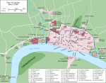
English: A map of London in 1300 from a historical atlas by William R Shepherd. Apart from religious foundations and two or three other complexes, the city is confined within its walls, which are well inside the present boundary of the City of London. The City is flanked to the east and west by the royal fortress of the Tower of London and the royal palace of Bridewell. The route from the city to the royal centre of Westminster is not yet fully built up. There is a settlement at Southwark, but it is very small.


Public domain

本作品在其來源國以及其他版權期限是作者逝世後70年或以下的國家與地區屬於公有領域


你必須增加美國公有領域標籤顯示為何這個作品在美國屬於公有領域。 請注意少數國家的著作權保護期為70年以上:墨西哥為100年,牙買加為95年,哥倫比亞為80年,瓜地馬拉與薩摩亞為75年,而這些國家不實施較短期限法則,因此該圖片可能在這些國家被認為是公有領域。宏都拉斯的著作權期限一般為75年,但該國實施較短期限法則。對於在第二次世界大戰期間為法國利益戰死的法國人(更多資訊)、二戰期間參與過蘇德戰爭(俄羅斯稱之為偉大的衛國戰爭)的俄羅斯人,以及蘇聯時期遭到鎮壓,而死後獲得平反的犧牲者(更多資訊),這些人的作品著作權期限會有所延長。

說明

添加單行說明來描述出檔案所代表的內容

在此檔案描寫的項目

描繪內容

威廉·謝潑德 中文 (已轉換拼寫)

多媒體型式 繁體中文 (已轉換拼寫)

image/png

檔案歷史

點選日期/時間以檢視該時間的檔案版本。

日期/時間縮⁠圖尺寸用戶備⁠註
目前2006年5月20日 (六) 18:20於 2006年5月20日 (六) 18:20 版本的縮圖700 × 536(644 KB)SiebrandHigher resolution from source
2005年10月25日 (二) 07:59於 2005年10月25日 (二) 07:59 版本的縮圖299 × 229(134 KB)JaT~commonswikiMap of London 1300

下列頁面有用到此檔案:

全域檔案使用狀況

以下其他 wiki 使用了這個檔案:

詮釋資料