
File:Bob 1991 rainfall.png

預覽大小:546 × 600 像素。 其他解析度:218 × 240 像素 | 437 × 480 像素 | 793 × 871 像素。
原始檔案 (793 × 871 像素,檔案大小:24 KB,MIME 類型:image/png)
摘要
| 描述 |
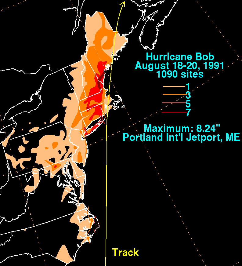
English: Storm total rainfall map of Hurricane Bob during August 1991. |
|||
| 日期 | ||||
| 來源 | WPC tropical cyclone rainfall data | |||
| 作者 | David Roth, Weather Prediction Center, Camp Springs, Maryland | |||
| 授權許可 (重用此檔案) |
|
原始上傳日誌
| 日期/時間 | 尺寸 | 用戶 | 備註 |
|---|---|---|---|
| 2010年四月24日, 15:52:03 | 793 × 871 (28384 bytes) | Cyclonebiskit (對話 · 貢獻) | {{Information |Description={{en|1=The beginnings of this tropical cyclone were along an old frontal boundary southeast of Bermuda on the 12th. Convection increased as it moved southwest and west over the next few days. By the morning of the 15th, a low |
檔案歷史
點選日期/時間以檢視該時間的檔案版本。
| 日期/時間 | 縮圖 | 尺寸 | 用戶 | 備註 | |
|---|---|---|---|---|---|
| 目前 | 2014年8月24日 (日) 12:31 | | 793 × 871(24 KB) | GifTagger | Bot: Converting file to superior PNG file. (Source: Bob_1991_rainfall.gif). This GIF was problematic due to non-greyscale color table. |
檔案用途
下列頁面有用到此檔案:
全域檔案使用狀況
以下其他 wiki 使用了這個檔案:
- en.wikipedia.org 的使用狀況
- sv.wikipedia.org 的使用狀況