
File:NHC Atlantic Forecast Error Trends.png

預覽大小:799 × 599 像素。 其他解析度:320 × 240 像素 | 640 × 480 像素 | 1,024 × 768 像素 | 1,280 × 960 像素 | 1,750 × 1,313 像素。
原始檔案 (1,750 × 1,313 像素,檔案大小:1.07 MB,MIME 類型:image/png)
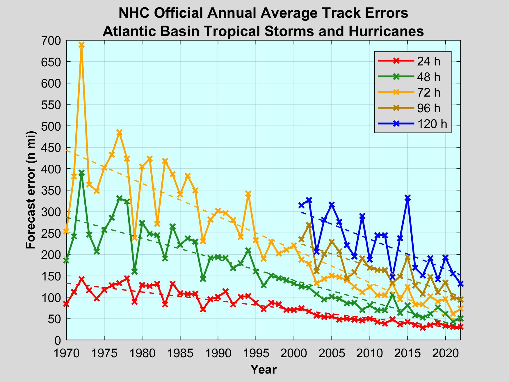
| 描述 | Error on the track since 1970 in Nautical miles. The different lines represent the forecasted position at different times prior to the verification (ex. 36h means the forecast made 36 h before the verification). |
| 日期 | (UTC) |
| 來源 | NOAA from National Hurricane Center Forecast Verification |
| 作者 | National Hurricane Center |
| 其他版本 | Image:NHC_Atlantic_Forecast_Error_Trends_FR.png |

|
本圖片是以PNG、GIF或JPEG格式上傳。然而,其中包含的資料或訊息,應該重新建立成可縮放向量圖形(SVG)檔案,以更有效率或更準確的方式儲存。如有可能,請上傳本圖片的SVG格式版本。在上傳之後,請修改維基各姊妹計畫中所有使用舊版圖片的條目(列在圖像連結章節中),替換為新版圖片,並在舊圖片的描述頁中加入{{Vector version available|新圖片名稱.svg}}模板,同時移除本模板。
|
本圖像屬於公有領域,因該作品最初來自於美國國家海洋和大氣管理局職員的職務作品。
|
檔案歷史
點選日期/時間以檢視該時間的檔案版本。
| 日期/時間 | 縮圖 | 尺寸 | 用戶 | 備註 | |
|---|---|---|---|---|---|
| 目前 | 2021年3月17日 (三) 17:37 | | 1,750 × 1,313(1.07 MB) | Femke | Update to around 2019 |
| 2015年8月24日 (一) 21:35 |  | 2,400 × 1,800(1.85 MB) | Pierre cb | Updated data up to 2014 | |
| 2009年5月27日 (三) 03:25 |  | 1,210 × 950(46 KB) | Pierre cb | Updated data from 1970 to 2007 | |
| 2009年5月26日 (二) 13:40 |  | 1,210 × 950(28 KB) | Mahahahaneapneap | Compressed | |
| 2008年1月28日 (一) 03:21 |  | 1,210 × 950(57 KB) | Pierre cb | {{Information |Description=Errror on the track since 1970 in Nautical miles. |Source= [http://www.nhc.noaa.gov/verification/figs/Early_model_ATL_trk_error_trend.gif NOAA] |Date=~~~~~ |Author=~~~ |Permission= |other_versions=[[:Image:NHC_Atlantic_Forecast |
檔案用途
下列頁面有用到此檔案:
全域檔案使用狀況
以下其他 wiki 使用了這個檔案:
- en.wikipedia.org 的使用狀況
- hi.wikipedia.org 的使用狀況
- pt.wikipedia.org 的使用狀況
- ru.wikipedia.org 的使用狀況
- simple.wikipedia.org 的使用狀況
- th.wikipedia.org 的使用狀況