跳至內容

File:The Blue Marble.jpg

頁面內容不支援其他語言。
這個檔案來自維基共享資源
維基百科,自由的百科全書

原始檔案 (2,320 × 2,407 像素,檔案大小:2.33 MB,MIME 類型:image/jpeg


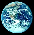
Taken with a Hasselblad 500EL camera and 80mm Zeiss lens at stop setting f/2.8 on 70mm Ektachrome film of type SO-368
藍色彈珠  wikidata:Q202014 reasonator:Q202014
作者

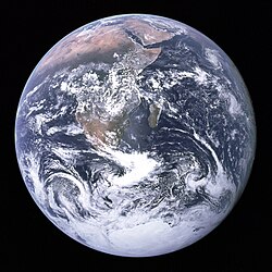
The photo was taken by the crew of Apollo 17 on their way to the Moon. Antarctica, Africa, the Arabian Peninsula, Madagascar, and part of Asia are visible.
Deglr6328's comments on modifying the image:

I cropped the image and adjusted only the brightness/contrast and gamma in photoshop to, what appears to my eye, be a better color match to what might actually be seen from space than the color in Image:The Earth seen from Apollo 17.jpg, which I feel is too dark/red and just odd looking (like an old faded photo). I tried to match the color in the version I uploaded to other examples of this shot as provided by NASA on various pages of theirs.
image of artwork listed in title parameter on this page
攝影師
夏里遜·施密特  (1935–) wikidata:Q108886
 
夏里遜·施密特
別名
哈里遜·舒密特
描述 美國地質學家、​政治人物、​太空人、​科學家以及大學教員
出生日期 1935年7月3日 在維基數據編輯
出生地點 聖麗塔 在維基數據編輯
創作地點
權威檔案
尤金·塞爾南  (1934–2017) wikidata:Q158486 q:en:Eugene Cernan
 
尤金·塞爾南
別名
出生名:Eugene Andrew Cernan; Eugene Cernan; 尤金·赛尔南; 尤金·塞爾南
描述 美國海軍軍官、​太空人、​戰機機師、​自傳作者、​商人以及military flight engineer
出生/逝世日期 1934年3月14日 在維基數據編輯 2017年1月16日 在維基數據編輯
出生/逝世地點 芝加哥 在維基數據編輯 侯斯頓 在維基數據編輯
權威檔案
羅納德·埃萬斯  (1933–1990) wikidata:Q313543
 
羅納德·埃萬斯
別名
罗纳德·埃文斯
描述 美國太空人、​軍官、​工程師、​飛機師以及military flight engineer
出生/逝世日期 1933年11月10日 在維基數據編輯 1990年4月7日 在維基數據編輯
出生/逝世地點 聖弗朗西斯 在維基數據編輯 斯科茨代爾 在維基數據編輯
權威檔案
 在維基數據編輯
標題
英文:
The Blue Marble 在維基數據編輯

《藍色彈珠》
title QS:P1476,en:"The Blue Marble 在維基數據編輯"
label QS:Len,"The Blue Marble 在維基數據編輯"
label QS:Les,"La canica azul"
label QS:Lis,"Bláa perlan"
label QS:Lms,"Guli Biru"
label QS:Lbg,"Синьото топче"
label QS:Ltr,"Mavi Bilye"
label QS:Lzh-hk,"藍色彈珠"
label QS:Lsv,"Den blå pärlan"
label QS:Luk,"Блакитна іграшкова куля"
label QS:Lzh-hant,"藍色彈珠"
label QS:Lzh-cn,"蓝色弹珠"
label QS:Lko,"푸른 구슬"
label QS:Leo,"Blua Globeto"
label QS:Lcs,"Modrá skleněnka"
label QS:Lbho,"दि ब्लू मार्बल"
label QS:Lbn,"দ্য ব্লু মার্বেল"
label QS:Lfr,"La Bille bleue"
label QS:Lanp,"द ब्लू मार्बल"
label QS:Lmr,"द ब्लू मार्बल"
label QS:Lvi,"Viên bi xanh"
label QS:Llv,"Zilā marmora bumbiņa"
label QS:Lsr,"The Blue Marble"
label QS:Lzh-sg,"蓝色弹珠"
label QS:Lsu,"Si Kaléci Biru"
label QS:Lckb,"کەلا شینەکە"
label QS:Lar,"البلية الزرقاء"
label QS:Lyue,"藍色波子"
label QS:Lhu,"Kék üveggolyó"
label QS:Leu,"Puxtarri urdina"
label QS:Lca,"La bala blava"
label QS:Lde,"Blue Marble"
label QS:Lga,"An Mirlín Gorm"
label QS:Lfa,"تیله آبی"
label QS:Lzh,"藍色彈珠"
label QS:Lja,"ザ・ブルー・マーブル"
label QS:Lhe,"The Blue Marble"
label QS:Lrmy,"I bodli marmura"
label QS:Lfi,"Sininen marmorikuula"
label QS:Lta,"தி புளூ மார்பிள்"
label QS:Lit,"Blue Marble"
label QS:Laz,"The Blue Marble"
label QS:Lsr-el,"The Blue Marble"
label QS:Lzh-mo,"藍色彈珠"
label QS:Lhr,"The Blue Marble"
label QS:Lmk,"Сина џамлија"
label QS:Lsr-ec,"The Blue Marble"
label QS:Lbe-tarask,"Блю марбл"
label QS:Lro,"The Blue Marble"
label QS:Lpt,"The Blue Marble"
label QS:Lvo,"Maboin Blövik"
label QS:Lnl,"Blue marble"
label QS:Lbe,"The Blue Marble"
label QS:Llt,"The Blue Marble"
label QS:Lsl,"Modra frnikola"
label QS:Ltl,"The Blue Marble"
label QS:Lth,"เดอะบลูมาร์เบิล"
label QS:Lhy,"Կապույտ մարբլ"
label QS:Lid,"Kelereng Biru"
label QS:Lpl,"The Blue Marble"
label QS:Lhi,"द ब्लू मार्बल"
label QS:Lsh,"The Blue Marble"
label QS:Lzh-tw,"藍色彈珠"
label QS:Lru,"The Blue Marble"
label QS:Lsc,"Sa Birìllia Asula"
label QS:Lsco,"The Blue Marble"
label QS:Lgl,"A canica azul"
label QS:Lbbc,"Garaga na biru"
label QS:Lzh-hans,"蓝色弹珠"
label QS:Let,"Sinine marmorkuul"
所屬實體 阿波羅17號 在維基數據編輯
物體類型 相片 在維基數據編輯
藝術類型 天文攝影 在維基數據編輯
描述
A version of The Blue Marble.
日期 This image was originally uploaded to the English Wikipedia by Deglr6328 on 04:05, 8 Mar 2005.
來源 The image is from [1] (NASA mission AS17, roll 148, frame 22727), specifically the 4400x4600 version available there.
其他版本
目標地點26° 19′ 49″ 南, 37° 25′ 13″ 東 Kartographer map based on OpenStreetMap.位於此地的本圖片與其他圖片: OpenStreetMapinfo

Other versions

[編輯]
Other versions:

Derivative works:

授權條款

Public domain 本作品由NASA創作,屬於公有領域。根據NASA的版權政策:“NASA的創作除非另有聲明否則不受版權保護。”(參見:Template:PD-USGov/zhNASA版權政策JPL圖像使用政策
警告:

說明

添加單行說明來描述出檔案所代表的內容
Earth (Antarctica, Africa and the Arabian Peninsula) as viewed from the Apollo 17 astronauts approximately 29,400 km away, on 7 December 1972 at 10:39 UTC

在此檔案描寫的項目

描繪內容

藍色彈珠 Chinese (Hong Kong) (已轉換拼寫)

改編自 Chinese (Hong Kong) (已轉換拼寫):​AS17-148-22727 英文
成立或建立時間:​7 12 1972

藍色彈珠 Chinese (Hong Kong) (已轉換拼寫)

改編自 Chinese (Hong Kong) (已轉換拼寫):​AS17-148-22727 英文

著作權狀態 繁體中文 (已轉換拼寫)

斷定方法:​美國聯邦政府的作品 繁體中文 (已轉換拼寫)

藍色彈珠 Chinese (Hong Kong) (已轉換拼寫)

描述地坐標 中文 (已轉換拼寫)

26°19'49.001"S, 37°25'13.001"E

多媒體型式 繁體中文 (已轉換拼寫)

image/jpeg

檔案歷史

點選日期/時間以檢視該時間的檔案版本。

日期/時間縮⁠圖尺寸用戶備⁠註
目前2023年10月28日 (六) 09:52於 2023年10月28日 (六) 09:52 版本的縮圖2,320 × 2,407(2.33 MB)Mykhaloriginal significat historical photo was corrected in place, while there are corrected derivatives as separate related photos - Reverted to version as of 22:13, 20 March 2005 (UTC)
2011年12月7日 (三) 05:11於 2011年12月7日 (三) 05:11 版本的縮圖3,000 × 3,002(6.69 MB)Ultimate RoadgeekThe old version seemed too cyan-heavy.
2005年3月20日 (日) 22:13於 2005年3月20日 (日) 22:13 版本的縮圖2,320 × 2,407(2.33 MB)Dbenbenndifferent color version of Image:The Earth seen from Apollo 17.jpg

全域檔案使用狀況