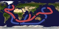
File:Thermohaline Circulation 2.png

本预览的尺寸:800 × 502像素。 其他分辨率:320 × 201像素 | 640 × 401像素 | 1,100 × 690像素。
原始文件 (1,100 × 690像素,文件大小:122 KB,MIME类型:image/png)
文件历史
点击某个日期/时间查看对应时刻的文件。
| 日期/时间 | 缩略图 | 大小 | 用户 | 备注 | |
|---|---|---|---|---|---|
| 当前 | 2008年3月29日 (六) 20:08 |  | 1,100 × 690(122 KB) | Dragons flight | {{Information |Description=This map shows the pattern of w:thermohaline circulation also known as "meridional overturning circulation". This collection of currents is responsible for the large-scale exchange of water masses in the ocean, including p |
文件用途
以下4个页面使用本文件:
全域文件用途
以下其他wiki使用此文件:
- ar.wikipedia.org上的用途
- ast.wikipedia.org上的用途
- az.wikipedia.org上的用途
- ba.wikipedia.org上的用途
- bcl.wikipedia.org上的用途
- be.wikipedia.org上的用途
- bg.wikipedia.org上的用途
- bh.wikipedia.org上的用途
- bn.wikipedia.org上的用途
- bs.wikipedia.org上的用途
- bxr.wikipedia.org上的用途
- ca.wikipedia.org上的用途
- cdo.wikipedia.org上的用途
- cs.wikipedia.org上的用途
- da.wikipedia.org上的用途
- da.wikibooks.org上的用途
- de.wikipedia.org上的用途
- el.wikipedia.org上的用途
- en.wikipedia.org上的用途
- Norwegian Sea
- Oceanography
- Talk:Ice
- Physical oceanography
- Thermohaline circulation
- Abrupt climate change
- Environmental isotopes
- Atlantic meridional overturning circulation
- Subantarctic
- Outline of oceanography
- Wild fisheries
- Sea
- Ocean
- User:Richard Hobbs/Seismic oceanography
- User:Vivrkn/sandbox
- Talk:Ice/GA1
- en.wikibooks.org上的用途
查看此文件的更多全域用途。


