
File:South Polar Cap of Mars during Martian South summer 2000.jpg

預覽大小:800 × 584 像素。 其他解析度:320 × 234 像素 | 640 × 467 像素 | 1,024 × 748 像素 | 1,280 × 935 像素 | 1,690 × 1,234 像素。
原始檔案 (1,690 × 1,234 像素,檔案大小:139 KB,MIME 類型:image/jpeg)
| 描述 |
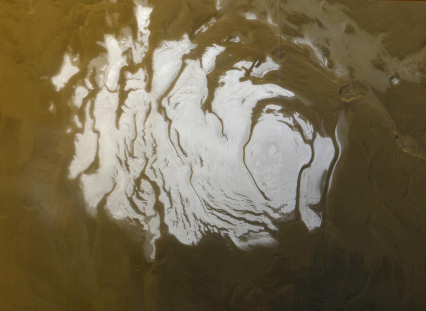
English: This is the south polar cap of Mars as it appeared to the Mars Global Surveyor (MGS) Mars Orbiter Camera (MOC) on April 17, 2000. The polar cap from left to right is about 420 km (260 mi) across.
Ελληνικά: Η νότια πολική περιοχή του πλανήτη Άρη. Εικόνα από τη διαστημοσυσκευή Mars Global Surveyor. Διακρίνεται εύκολα το κάλυμμα πάγου του Νότιου Πόλου, που εδώ έχει διάμετρο περίπου 420 km. Η φωτογραφία έχει ληφθεί κατά τη διάρκεια του καλοκαιρού στο Νότιο ημισφαίριο, κι έτσι η έκταση του πάγου είναι η ελάχιστη που σημειώνεται, καθώς κατά τη διάρκεια του καλοκαιριού το κάλυμμα πάγου στους πόλους του Άρη συρρικνώνεται. Κατά το χειμώνα, ολόκληρη η περιοχή που φαίνεται στη φωτογραφία σκεπάζεται με πάγο.
Original captionThis is the south polar cap of Mars as it appeared to the Mars Global Surveyor (MGS) Mars Orbiter Camera (MOC) on April 17, 2000. In winter and early spring, this entire scene would be covered by frost. In summer, the cap shrinks to its minimum size, as shown here. Even though it is summer, observations made by the Viking orbiters in the 1970s showed that the south polar cap remains cold enough that the polar frost (seen here as white) consists of carbon dioxide. Carbon dioxide freezes at temperatures around -125° C (-193° F). Mid-summer afternoon sunlight illuminates this scene from the upper left from about 11.2° above the horizon. Soon the cap will experience sunsets; by June 2000, this pole will be in autumn, and the area covered by frost will begin to grow. Winter will return to the south polar region in December 2000. The polar cap from left to right is about 420 km (260 mi) across. |
|||||
| 日期 | ||||||
| 來源 | http://photojournal.jpl.nasa.gov/catalog/PIA02393 http://www.msss.com/mars_images/moc/4_27_00_spcap/ file | |||||
| 作者 | NASA/JPL/MSSS | |||||
| 授權許可 (重用此檔案) |
|

| 此標籤不表示文件的著作權狀態。任何文件在附有此標籤的同時還需要一個有效的著作權標籤。請參閱許可協議說明頁面以了解更多資訊。 其他語言:
|
檔案歷史
點選日期/時間以檢視該時間的檔案版本。
| 日期/時間 | 縮圖 | 尺寸 | 使用者 | 備註 | |
|---|---|---|---|---|---|
| 目前 | 2011年10月2日 (日) 10:10 | | 1,690 × 1,234(139 KB) | Badseed | {{Information |Description={{en|This is the south polar cap of Mars as it appeared to the Mars Global Surveyor (MGS) Mars Orbiter Camera (MOC) on April 17, 2000. The polar cap from left to right is about 420 km (260 mi) across.}} {{el|Η νότια πολ |
檔案用途
下列5個頁面有用到此檔案:
全域檔案使用狀況
以下其他 wiki 使用了這個檔案:
- ar.wikipedia.org 的使用狀況
- az.wikipedia.org 的使用狀況
- ca.wikipedia.org 的使用狀況
- de.wikipedia.org 的使用狀況
- el.wikipedia.org 的使用狀況
- en.wikipedia.org 的使用狀況
- en.wikiversity.org 的使用狀況
- es.wikipedia.org 的使用狀況
- et.wikipedia.org 的使用狀況
- eu.wikipedia.org 的使用狀況
- fa.wikipedia.org 的使用狀況
- fr.wikipedia.org 的使用狀況
- he.wikipedia.org 的使用狀況
- hi.wikipedia.org 的使用狀況
- hr.wikipedia.org 的使用狀況
- hu.wikipedia.org 的使用狀況
- id.wikipedia.org 的使用狀況
- kw.wikipedia.org 的使用狀況
- mnw.wikipedia.org 的使用狀況
- pl.wikipedia.org 的使用狀況
- pt.wikipedia.org 的使用狀況
- pt.wikibooks.org 的使用狀況
- ru.wikipedia.org 的使用狀況
- simple.wikipedia.org 的使用狀況
- sl.wikipedia.org 的使用狀況
- sr.wikipedia.org 的使用狀況
- th.wikipedia.org 的使用狀況
- uk.wikipedia.org 的使用狀況
- vi.wikipedia.org 的使用狀況
- www.wikidata.org 的使用狀況