
巴勒斯坦地名的希伯來化
| 本条目属系列条目 |
| 阿利亞運動 |
|---|
 |
| 概念 |
| 前现代阿利亚运动 |
| 现代阿利亚运动 |
| 吸纳 |
| 组织 |
| 相关主题 |


在英屬巴勒斯坦的不同時間,該地區有不少地名都使用希伯来语來命名。在1948年,經過巴勒斯坦人大逃亡和阿以戰爭之後,以色列建國。隨後,以色列在1967年的六日戰爭期間占領了巴勒斯坦领土[2] 。1992年的一項研究計算,共有約 2780 名被希伯來化的歷史古跡名字,包括:340個村鎮、1千多個遺址、560條河流、380個泉水、198座山丘、50個洞穴、28座城堡和宫殿、以及14個水池和湖泊[3]。巴勒斯坦人普遍認爲,巴勒斯坦地名的希伯來化是巴勒斯坦大災難的一部分[4]。
巴勒斯坦的不少地名,都是古代希伯來語或迦南語言的阿拉伯化形式,而許多本來的名字都能在希伯來聖經和塔木德中找到[5][6]。這些名字大多已經流傳了幾千年,但名字背後的含義不少都已經失傳。在古典时期和古代晚期期間,該地區的地區逐漸演變成亞拉姆語和古希臘語[7] [8],也就是伊斯兰教出现之前主要使用的兩種語言[8] [9]。穆斯林征服黎凡特以後,該地區的名稱開始被阿拉伯化。
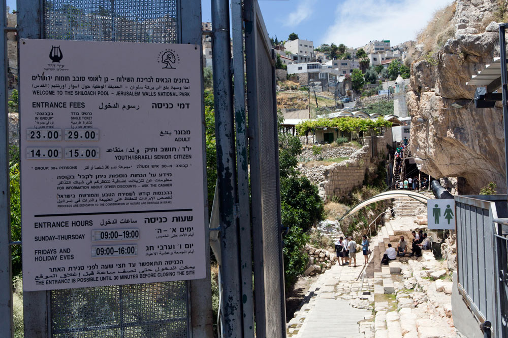
以色列政府鼓勵地名的希伯來化,爲了增强在阿利亞運動到以色列的猶太人新移民對該地方提供聯係[10]。因此,不少希伯來聖經或塔木德的地名都被恢復[11],而且不少本身只有阿拉伯名字而沒有希伯來名字的地方,都有了新的希伯來地名[12] 。但是也有一些情況,在現代希伯來語的名字,保留了原本的巴勒斯坦阿拉伯語名字。例如,現時的 “Banias” ,在古典希伯来语中該作“Paneas”[13]。在國營的政府機構的路標和地圖裏,常常會並列希伯來和阿拉伯的名字,例如“Nablus / Shechem”和“Silwan / Shiloach”等[14]。
在以色列某些地區,特别是猶太人-巴勒斯坦人混居的地方,有些街道的名字恢復了希伯來化以前的阿拉伯名字[15] [16]。
早期歷史


巴勒斯坦探索基金會的克勞德·康德很早就知道,分析當今的阿拉伯地名,對分辨更古老的希伯來語名稱非常重要。康德沒有消除他《西巴勒斯坦調查》地圖中的阿拉伯地名,倒是完整地保留了它們的名稱[18]。在他的回憶錄中,他注意到希伯來語和阿拉伯語的地名傳統,通常都是一致的:
聖經中提到的舊城鎮和村莊的名稱大部分幾乎沒有改變... 事實上,由於每個名字都使用阿拉伯字母來仔細記錄,所以可以使用科學和學術的方式,來與希伯來語進行比較... 當希伯來語和阿拉伯語的地名,被證明包含相同的部首、喉音、和含義時,我們就有了真正可靠的比較... 我們現在已經恢復了聖經地名中的超過四分之三,也因此可以自信地說,聖經的地形圖是真實的、也同時是熟悉該國的希伯來人所創作的作品[19]。
現代過程的早年
現代的希伯來化,由1880年代的首潮阿利亞運動之後開始[20]。1920年代,HeHalutz 的青年運動開始了為在英屬巴勒斯坦的新建定居點,設置希伯來化的計劃[21]。 然而,這些希伯來名稱僅適用於猶太國家基金會 (JNF) 購買的土地,因為它們對以外的其他地名沒有影響力。
該時候,那裏的方向路標經常只用阿拉伯語和英文的音譯,而沒有相應的希伯來語書寫。該地區猶太社區,在大衛·耶林等著名錫安主義者的領導下,曾經試圖影響皇家地理學會(RGS)的地名常設委員會[20],以使命名會考慮希伯來語的名字[22]。
儘管如此,現今位於該地區的主要地名,阿拉伯與希伯來的名字兩個都受使用,例如耶路撒冷(Jerusalem / Al Quds / Yerushalayim)和希伯侖(Hebron / Al Khalil / Hevron)[23]。但同時,也有一些比較鮮為人知的古代猶太遺址,保留了阿拉伯名字,包括:Jish / Gush Halav、Beisan / Beit She'an、Shefar-amr / Shefar'am、Kafr'Inan / Kefar Hananiah、Bayt Jibrin / Beit Gubrin 等等[24][25]。
其中反對為古希伯來地名添加額外拼寫的主要因素之一,是擔心會為郵政服務造成混亂,因爲不少的名字已經被長期使用而習慣了。因此,英國官員尋求確保地名的統一形式,確保地圖上的名稱會保持一致[26]。
儘管 RGS 名稱委員會試圖反對,但依舒夫成員堅持將希伯來語名稱應用於古老的阿拉伯名稱。不同的歷史地理學家,無論是猶太人還是非猶太人[22],都相信:這個決定的動機之一,是源於覺得阿拉伯地名僅僅是舊希伯來語名稱的「訛誤」[27],例如 Khirbet Shifat = Yodfat;Khirbet Tibneh = Timnah[28] [29];Lifta = Nephtoah[30];Jabal al-Fureidis = Herodis 等。
在某些時候,為一個地方「恢復希伯來語的名稱」的歷史過程中,又錯又混亂。例如,在為阿拉伯村 Iraq al-Manshiyya 改名初期,該鎮被命名為 Tel Gath,因爲是根據聖經學家威廉·奧爾布賴特,把該鎮與聖經中的迦特(Gath)連上關係。但當後來發現這地名不當時,改了名為 Tel Erani ,但又被發現同樣是誤名,到之後才再改爲現時的迦特鎮 ( Kiryat Gat ) 。
根據維珍尼亞·提莉教授的說法,「不同在科學、語言、文學、歷史、和聖經權威中的機構的發明,是為了培養猶太人對猶太家園的歸屬感和自然權利的印象。而這些印象,是從猶太人對這片幾千年來,被不同民族控制的土地上,擁有的特殊權利而復制出來的」[31]。
早在1920年,英國政府已經在巴勒斯坦成立了希伯來語的小組委員會,爲了就地名英文抄本向政府提供建議,並確定官方使用的希伯來語地名形式[32]。
猶太國家基金命名委員會
1925 年,猶太國家基金會 (JNF) 成立了定居點命名委員會,旨在為 JNF 購買的土地上,建立的新猶太人定居點命名[33], 並由 JNF 領導人梅納赫姆·烏斯西什金直接領導[34]。 猶太全國委員會 (JNC) 則於1931年底舉行談判,向英屬巴勒斯坦政府提出建議,對英國駐巴勒斯坦的殖民辦公室出版的一本譯名書進行修改。該書概述了阿拉伯語、希伯來語、與英語之間的地名翻譯,以確保英方使用統一的標準。JNC 許多的提案後來得到實施,從1949年地名委員會開始,到1951年,耶沙亞胡·普雷斯( JNC成員之一)成立了政府命名委員會[35]。
以色列政治學家梅龍·本韋尼斯提寫道,阿拉伯地名讓新的猶太社區感到不安。1941年4月,澤武倫地區委員會會寫了信給 JNF 總部[36]:
以下這些名字都展現在他們的榮耀中:卡巴薩、謝赫·沙馬利、阿布·蘇蘇克、布斯坦·沙馬利——所有這些名字 JNF 都沒有興趣在 澤武倫山谷永垂不朽... 我們建議您向澤武倫山谷及其附近的 JNF 土地上的所有定居點發送一封通函,警告他們不要繼續上述的做法(即使用舊地圖),因為這從各個角度來看都是危險的。
從1925到1948年間,猶太國家基金會的命名委員會為巴勒斯坦的215個猶太社區命名[20]。 儘管改了地名,但舊的地圖上仍保留了它們的舊地名的記錄[37]。
阿拉伯語的語言優勢
到1931年,英方的不同官方機構列出的地名,包括在郵局、火車站、與電話簿等,都刪除了不少希伯來語的地名,包括 "Shechem"(Nablus)、"Nazareth" 和 "Nahal Sorek"(Wadi es-Sarar)。這事引起了猶太全國委員會的關注,認為英屬巴勒斯坦政府對其猶太公民有偏見[38]。Nahal Sorek 是在從耶路撒冷乘火車到哈爾圖夫期間的主要路線和通道。
內蓋夫地名指定委員會
在1949年末,第一次中東戰爭結束後,以色列的新政府成立了內蓋夫地區的地名指定委員會。該委員會由9名學者組成,而他們的任務就是為該地區的城鎮、山脈、山谷、泉水、道路等分配希伯來名字[39]。 以色列總理大衛·本-古裡安在同年較早已決定了該地區重新命名的重要性,並曾在7月份的日記中寫道:「我們必須給這些地方起希伯來語的名字——如果有的話,就用古名字;如果沒有的話,就用新的!」[40]。他隨後在給委員會主席的一封信中,確定了該委員會的目標[39]:
出於國家原因,我們有義務刪除阿拉伯名字。正如我們不承認阿拉伯人對這片土地的政治擁有權一樣,我們也不承認他們的精神擁有權和名字。
在內蓋夫,委員會決定的 533 個新名字之中,有 333 個是由阿拉伯名字而來的音譯或其他發音相似的名字。 本韋尼斯提表示,委員會的一些成員曾反對消除阿拉伯地名,但在許多情況下,他們由出於政治和民族主義的考慮而被否決[41]。
政府命名委員會
1951年3月,猶太國家基金委員會和內蓋夫委員會合并,創建了政府命名委員會,以覆蓋以色列全境。該委員會表示:「我國地名的猶太化是一個至關重要的問題」。1960年2月,以色列測量局局長約瑟夫·埃爾斯特寫道:「我們已經確定,用希伯來語名稱替換阿拉伯名稱的工作尚未完成。委員會必須迅速填補缺失的內容,尤其是廢墟的名稱」[42]。1951年4月,伊扎克·本-兹维和便雅憫·馬扎爾博士被任命為委員會的成員[43]。
1920年至1990期間,不同委員會為該國大約7000多個使用了自然元素來改名,其中5000多個是地理地名,數百個是歷史遺址的名稱,而1000多個是新定居點的名稱。 地理學家澤夫·維勒內指出,自19世紀以來,不少聖經單詞、表達方式、和短語,為現代的以色列提供了許多城鄉定居點和社區的名稱[44]。
雖然許多較新的猶太定居點名稱,已經取代了較舊的阿拉伯村莊和廢墟名稱(例如 Khirbet Jurfah → Roglit [45][46];Allar → Mata;al-Tira → Kfar Halutzim → Bareket 等),但本韋尼斯提也表明這些歷史悠久的地名並沒有完全消失[47]:
如今,如果新定居點的名稱不能以某種方式與鄰近地區或地區聯系起來,以色列政府命名委員會不鼓勵為新定居點命名。盡管如此,它仍然是唯一授權的名稱仲裁者,無論該名稱是否與該網站有歷史聯系[48]。
現今趨勢
到2010年代,開始恢復原始阿拉伯語的街道名稱的趨勢,很多是位於以色列的猶太-阿拉伯混合地區,自1948年起已被希伯來化[15][16]。
參考來源
- ^ Masalha, Nur. Palestine: A Four Thousand Year History. Zed Books. 15 August 2018. ISBN 978-1-78699-275-8.
APPROPRIATION, HYBRIDISATION AND INDIGENISATION: THE APPROPRIATION OF PALESTINE PLACE NAMES BY EUROPEAN ZIONIST SETTLERS. From Palestinian Fuleh to Jewish Afula. The etymology of the Zionist settler toponym Afula is derived from the name of the Palestinian Arab village al‐Fuleh, which in 1226 Arab geographer Yaqut al‐Hamawi mentioned as being a town in the province of Jund Filastin. The Arabic toponym al‐Fuleh is derived from the word ful, for fava beans, which are among the oldest food plant in the Middle East and were widely cultivated by local Palestinians in Marj Ibn 'Amer [Jerzeel Valley].
- ^ Kadman, Noga. Naming Jewish Communities on or Near the Sites of Depopulated Villages. Naming and Mapping the Depopulated Village Sites. Indiana University Press. 2015-09-07: 91– [2023-11-24]. ISBN 978-0-253-01682-9. (原始内容存档于2023-08-17).
- ^ Study by Palestinian geographer {{link-ar|舒克里·阿拉夫|شكري عراف]] (1992), "The Palestinian locations between two eras/maps" (Arabic). Kufur Qari’: Matba’at, Al-Shuruq Al-Arabiya; quoted in Amara 2017
- ^ Sa'di, Ahmad H. Catastrophe, Memory and Identity: Al-Nakbah as a Component of Palestinian Identity. Israel Studies. 2002, 7 (2): 175–198 [2023-11-24]. JSTOR 30245590. S2CID 144811289. doi:10.2979/ISR.2002.7.2.175. (原始内容存档于2023-01-18).
Al-Nakbah is associated with a rapid de-Arabization of the country. This process has included the destruction of Palestinian villages. About 418 villages were erased, and out of twelve Palestinian or mixed towns, a Palestinian population continued to exist in only seven. This swift transformation of the physical and cultural environment was accompanied, at the symbolic level, by the changing of the names of streets, neighborhoods, cities, and regions. Arabic names were replaced by Zionist, Jewish, or European names. This renaming continues to convey to the Palestinians the message that the country has seen only two historical periods which attest to its "true" nature: the ancient Jewish past, and the period that began with the creation of Israel.
- ^ Conder, C. R. Palmer, E. H. , 编. Survey of Western Palestine: Arabic and English Name Lists. Committee of the Palestine Exploration Fund. 1881: iv-v.
To determine the exact meaning of Arabic topographical names is by no means easy. Some are descriptive of physical features, but even these are often either obsolete or distorted words. Others are derived from long since forgotten incidents, or owners whose memory has passed away. Others again are survivals of older Nabathean, Hebrew, Canaanite, and other names, either quite meaningless in Arabic, or having an Arabic form in which the original sound is perhaps more or less preserved, but the sense entirely lost. Occasionally Hebrew, especially Biblical and Talmudic names, remain scarcely altered.
- ^ Rainey, 1978, p.230: “What surprised western scholars and explorers the most was the amazing degree to which biblical names were still preserved in the Arabic toponymy of Palestine”
- ^ Mila Neishtadt. 'The Lexical Substrate of Aramaic in Palestinian Arabic,' in Aaron Butts (ed.) Semitic Languages in Contact, BRILL 2015 pp.281-282:'As in other cases of language shift, the supplanting language (Arabic) was not left untouched by the supplanted language (Aramaic) and the existence of an Aramaic substrate in Syro-Palestinian colloquial Arabic has been widely accepted. The influence of the Aramaic substrate is especially evidence in many Palestinian place names, and in the vocabularies of traditional life and industrials: agriculture, flora, fauna, food, tools, utensils etc.'
- ^ 8.0 8.1 Rainey, 1978, p.231: “In the majority of cases, a Greek or Latin name assigned by Hellenistic or Roman authorities enjoyed an existence only in official and literary circles while the Semitic- speaking populace continued to use the Hebrew or Aramaic original. The latter comes back into public use with the Arab conquest. The Arabic names Ludd, Beisan, and Saffurieh, representing original Lod, Bet Se’an and Sippori, leave no hint concerning their imposing Greco-Roman names, viz., Diospolis, Scythopolis, and Diocaesarea, respectively”
- ^ Mila Neishtadt. 'The Lexical Substrate of Aramaic in Palestinian Arabic,' in Aaron Butts (ed.) Semitic Languages in Contact, BRILL 2015 pp.281-282:'As in other cases of language shift, the supplanting language (Arabic) was not left untouched by the supplanted language (Aramaic) and the existence of an Aramaic substrate in Syro-Palestinian colloquial Arabic has been widely accepted. The influence of the Aramaic substrate is especially evidence in many Palestinian place names, and in the vocabularies of traditional life and industrials: agriculture, flora, fauna, food, tools, utensils etc.'
- ^ Cohen, Saul B.; Kliot, Nurit. Place-Names in Israel's Ideological Struggle over the Administered Territories. Annals of the Association of American Geographers. 1992-12-01, 82 (4): 653–680 [2023-11-24]. ISSN 0004-5608. doi:10.1111/j.1467-8306.1992.tb01722.x. (原始内容存档于2023-04-18).
- ^ Miller and Hayes, 1986, p. 29.
- ^ Swedenburg, 2003, p. 50.
- ^ Vilnay, Zev (1954), p. 135 (section 9). Cf. Targum Shir HaShirim 5:4; etc. The reason for the hard-sounding "b" in the Arabic pronunciation of Banias has to do with the fact that, in the Arabic language, there is no hard "p" sound; the "p" being replaced by "b".
- ^ Sign welcoming visitors to Siloam (Shiloach), printed both in Hebrew and Arabic with traditional names (页面存档备份,存于互联网档案馆), B'Tselem, 16 September 2014
- ^ 15.0 15.1 Rekhess. The Arab Minority in Israel: Reconsidering the "1948 Paradigm". Israel Studies. 2014, 19 (2): 187–217. JSTOR 10.2979/israelstudies.19.2.187. S2CID 144053751. doi:10.2979/israelstudies.19.2.187.
A new trend that has become particularly popular in recent years in mixed Jewish-Arab cities, is attempts to restore original Arabic street names, “Hebraized” after 1948
- ^ 16.0 16.1 Ofer Aderet. A stir over sign language: A recently discovered trove of documents from the 1950s reveals a nasty battle in Jerusalem over the hebraization of street and neighborhood names. This campaign is still raging today.. 国土报. 29 July 2011 [18 December 2011]. (原始内容存档于2023-05-01).
- ^ Rainey, 1978, p.231
- ^ Hopkins, I.W.J. (1968), p. 34. Quote: "Conder collected the current Arabic names for the places on his [P.E.F.] maps, which on the face of it makes them appear to be less useful, compared with Jacotin's [map]. In fact, this makes the P.E.F. map even more useful as evidence of the current Arab place name, and the sheets are not cluttered up with doubtful identifications. The Arabic name is often a corruption of the ancient name and this fact has helped enormously in locating Biblical, Classical and Byzantine sites."
- ^ Conder, Major C. R. (n.d.), pp. 218–219
- ^ 20.0 20.1 20.2 Fields, Gary. Enclosure: Palestinian Landscapes in a Historical Mirror. Univ of California Press. 5 September 2017: 222. ISBN 978-0-520-29104-1.
- ^ Boaz Neumann. Land and Desire in Early Zionism. UPNE. 2011: 167. ISBN 978-1-58465-968-6.
- ^ 22.0 22.1 Maisler et al. 1932,第3-5 (Preface)頁.
- ^ Adler, Elkan Nathan (2014), pp. 225, et al.
- ^ British Colonial Office in Palestine (1931), pp. 1, 13, 37, 52, 54–56, 59, 65. Quote: (p. 2) "The list of geographical names has presented many difficulties. Many place names in Palestine are of Arabic origin while others are of Hebrew, Phoenician, Greek, Latin, or Frankish ancestry –– to mention only the most important sources –– but, as most places are inhabited by Arabic-speaking people, local usage has given them names in Arabicised forms or in colloquial Arabic. To adopt the colloquial forms in transliterating names was not considered consistent with the end in view, and as a general rule an effort has been made to put the names in as literary a garb as possible. In most names of Arabic origin this was comparatively easy; but in some the Arab experts recommended the retention of forms not usually admitted in Arabic grammatical word construction."
- ^ Gleichen, Edward, ed. (1925). Quote: (Preface) "The following List of Names in Palestine, having been submitted through H.M. Secretary of State for the Colonies to the High Commissioner, and referred by him for correction to special Arabic and Hebrew subcommittees, is now published by the Permanent Committee on Geographical Names for British Official use."
- ^ Gleichen, Edward (1920), p. 309
- ^ Benvenisti, M. (2000), pp. 47–48. Quote: "The Arab conquerors who colonized the land following the conquest of 638 C.E. settled among its Jewish, Samaritan, and Christian natives. They easily assimilated the Hebrew-Aramaic geographical and topographical names, and, their language being closely related to the Semitic languages spoken there, they made only slight changes in spelling and pronunciation. They had no difficulty finding Arabic forms for names such as Ashkelon –– which they transformed into Asqalan –– Beit Horon to Beit Ghur, Beersheba to Bir Saba'a, and Eilat to Aila."
- ^ Clermont-Ganneau (1896), pp. 67–68, 214, where he wrote: (p. 214) "Tibneh, 'chopped straw', one would swear was Arabic, but it is beyond a doubt that it is the name of the town Timnah, brought into that shape by one of those popular etymologies which are as dear to the peasantry of Palestine as to those of our European countries." On pp. 67–68 he wrote: "One has to beware, however, of these appellations that appear to be of purely Arabic origin, they are often ancient Hebrew names converted by a process of popular etymology into words familiar to the Arabs. In many cases slight phonetic changes assist the process. These, by the bye, are not arbitrary, but are subject to real laws. Thus, for instance, the name of the Bible town of Thimnah has become in fellâh speech Tibneh, 'chopped straw'."
- ^ Robinson, E. (1860), p. 17. See alao John William McGarvey (1829–1911) who quotes Conder on the linguistic evidence of the name, saying that, in Arabic, "the substitution of B for M is so common (as in Tibneh for Timnah)..." See: McGarvey, 2002, pp. 246-247; cf. Palmer, E.H. (1881), p. 330, s.v. Tibna
- ^ Kampffmeyer, Georg (1892), p. 38 (section 15)
- ^ Tilley (2005), p. 190
- ^ Bitan 1992,第366頁.
- ^ Ettinger, Y. Determining the Names of the Settlements acquired by the Jewish National Fund. Davar. 25 August 1925 [2023-11-24]. (原始内容存档于2023-05-01) (希伯来语).
- ^ Benvenisti 2000,第26頁.
- ^ State of Israel Records, Collection of Publications, no. 277 (PDF), Jerusalem: Government of Israel: 630, 1953 [2023-11-24], (原始内容存档 (PDF)于2023-04-19) (希伯来语),
The names of the settlements were mostly determined at different times by the 'Names Committee for the Settlements,' under the auspices of the Jewish National Fund (est. 1925), while [other] names were added by the Government Naming Committee.
- ^ Benvenisti 2000,第30頁.
- ^ A British Mandate map, contained at the National Library of Israel (Eran Laor Cartographic Collection (页面存档备份,存于互联网档案馆), Jaffa: Survey of Palestine 1928 – 1947, "Palestine" (Pal 1157)); an Ottoman period map, the Palestine Exploration Fund Map, published by the Israel Antiquities Authority SWP web-site (页面存档备份,存于互联网档案馆), and which is chiefly studied by archaeologists and historical geographers when trying to determine what Arabic place names are representative of ancient Hebrew toponymy. Other online maps include: George A. Smathers Libraries: Survey of Palestine map (页面存档备份,存于互联网档案馆); The Palestine Exploration Fund Maps (页面存档备份,存于互联网档案馆), published by The Digital Archaeological Atlas of the Holy Land; McMaster University - Digitalised maps of Palestine / Israel (页面存档备份,存于互联网档案馆); 1944 Map of Palestine (页面存档备份,存于互联网档案馆), published by the National Library of Israel.
- ^ Maisler et al. 1932,第6頁.
- ^ 39.0 39.1 Benvenisti 2000,第12頁.
- ^ Nur Masalha. The Palestine Nakba: Decolonising History, Narrating the Subaltern, Reclaiming Memory. Zed Books Ltd. 9 August 2012: 72– [2023-11-24]. ISBN 978-1-84813-973-2. (原始内容存档于2023-08-17).
- ^ Benvenisti 2000,第17頁.
- ^ Benvenisti 2000,第40頁.
- ^ State of Israel Records, Collection of Publications, no. 152 (PDF), Jerusalem: Government of Israel: 845, 1951 [2023-11-24], (原始内容存档 (PDF)于2023-04-19) (希伯来语)
- ^ Vilnay 1983,第Abstract頁.
- ^ In the Survey of Western Palestine (Arabic and English Name Lists), London 1881, p. 307, E.H. Palmer describes the site Khŭrbet Jurfa as "the ruin of the perpendicular bank (cut out by the torrent in the débris of a valley)."
- ^ Avner, Rina. Rogelit. Hadashot Arkheologiyot: Excavations and Surveys in Israel (Israel Antiquities Authority). 2006, 118 [2023-11-24]. (原始内容存档于2023-01-08) (英语).
- ^ Benvenisti 2000,第49頁.
- ^ In the case of Kiryat Sefer (now Modi'in), a name rejected by the Committee in 1994 on grounds that the biblical Kiryat Sefer was located elsewhere, or in the case of Neveh Tzuf, which name was rejected by the Committee (HCJ 146/81) for Halamish, on grounds that a "historical name is not to be copied elsewhere," these names were decided strictly by the Committee, based on Government Statute No. 258 of March 8, 1951, in which it gave to the Government Naming Committee the sole responsibility for the naming of settlements. This decision states that the aforesaid Committee will act in the Prime Minister's Office and that its decisions will be binding upon state institutions: "The committee is the only competent body for determining names for various localities and sites, including intersections, interchanges, tourist sites, nature and landscape, industrial and employment sites and the like in the State of Israel." The Committee's decisions are made in its plenary and published in "Records".